Explore the Matakana Coast
The Matakana Coast, just an hour north of Downtown Auckland and on the northwest side of the Hauraki Gulf, is one of New Zealand’s most appealing coastal regions. With golden and white sand beaches, marine reserves, boutique wineries, attractive towns and beautiful forest tracks, it’s a destination where small towns and hidden coves sit alongside some of Auckland’s best-known regional parks.
Warkworth and Mahurangi
The southern gateway to the Matakana Coast is Warkworth, a historic riverside town on the Mahurangi River. Cafés, shops, and a riverside walkway make it an easy stop on the way north. At the south end of the town is the Parry Kauri Forest Reserve, a lesser-known gem that includes two big mature kauri trees, superb walks through a regrowth forest and a small museum telling the story of the district. To the southeast is the Mahurangi Peninsula and Harbour, and to the north is Matakana, Tawharanui, Ōmaha and Leigh.
A short drive south of Warkworth on the Twin Coast Discovery Highway is Mahurangi Regional Park on the west side of the Mahurangi Harbour, with sheltered beaches, rugged hills and camping. There is also a short hike in a recovered native forest nearby at Pohuehue. Heading onto the Mahurangi Peninsula, there is Scotts Landing, Snells Beach and Scandrett Regional Park, a farm-park setting by the sea. All are superb for picnics, coastal walks, and swimming in safe bays. Martins Bay is another exceptional beach just beyond Scandrett.
Matakana Village and Vineyards
Heading north of Warkworth on Matakana Road is the town of Matakana, the region’s hub. It has a lively Saturday market, a boutique cinema, cafés and shops, making it a weekend favourite. Surrounding hills are dotted with vineyards, olive groves, and artists’ studios, many of them open to visitors. A short walk along the Matakana River also takes you to a waterfall and a historic river jetty, while the public toilets are second only to the Kawakawa toilets!


Tāwharanui Peninsula
Continuing north from Matakana provides access to Tāwharanui Regional Park, the crown jewel of the Matakana Coast. This park is a predator-free open sanctuary where native birds flourish in a strip of native forest, and tracks lead from rolling farmland to pōhutukawa-fringed beaches. It is the most accessible onshore sanctuary in the Auckland region. Offshore, the Tāwharanui Marine Reserve protects marine life.
Hidden on the southern side of the peninsula are Buckleton, Baddeleys and Campbells Beaches, with sheltered coves shaded by incredible old pōhutukawa trees, backed by grassy reserves perfect for swimming, boating, and picnics.
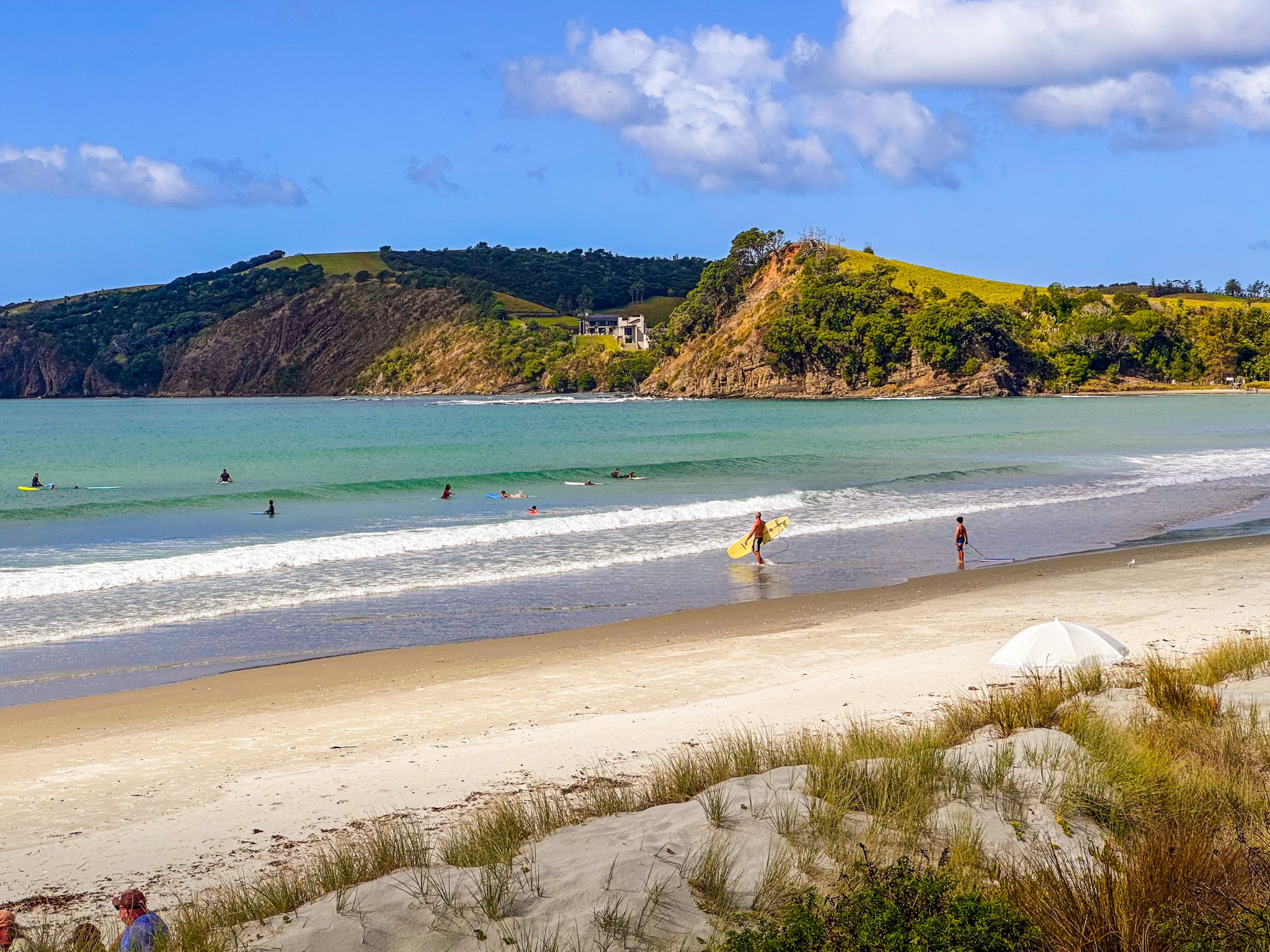
Ōmaha – Surf Beach and Dunes
North of the peninsula lies Ōmaha, a modern beach community spread along a spectacular white-sand surf beach, reached on a bridge that crosses the Whangateau Harbour. The beach faces west into Little Ōmaha Bay and the Hauraki Gulf. It is patrolled by lifeguards from Labour Weekend to Easter, and it is a popular spot for swimming and surfing. Behind the beach, extensive dunes protect the coastline, and there are extensive tracks through restored plantings of spinifex and pīngao.
Ōmaha has developed into one of the most upmarket holiday communities in Auckland, with architect-designed homes, especially at the eastern end of the beach. However, the natural setting still dominates, with wide, uninterrupted sea views and open skies. The Ōmaha Spit Shorebird Sanctuary protects endangered dotterels and other seabirds behind a predator-proof fence.
Ti Point, Matheson Bay, Leigh, and Goat Island
To the north of Ōmaha lies Ti Point, with a wonderful coastal hiking track, followed by Kohuroa / Matheson Bay, a small, sheltered beach popular with families and dive schools. A special surprise here is the Kohuroa Stream Track, a short forest walk with waterfalls, swimming holes, and groves of kauri and rimu.
Further north, the fishing village of Leigh looks out over Omaha Cove and serves as the gateway to Te Hāwere-a-Maki / Goat Island Marine Reserve, New Zealand’s first and most famous marine reserve. Snorkelling, diving, and glass-bottom boat tours reveal an abundance of fish and kelp forests. The Leigh Coastal Walk is also a highlight, with cliff-top tracks providing sweeping sea views.
Pakiri and the Northern Beaches
North of Leigh, the coast opens to long white beaches at Pakiri and Te Ārai. Pakiri Beach is both a surf spot and a wild, windswept stretch of sand where horse treks, camping, and fishing are popular. It also connects to Te Araroa, which runs down the beach and then inland through the region.
Māori History
The Matakana Coast has long been a place of abundance for mana whenua, including Ngāti Manuhiri, Ngāti Rongo, and Ngāti Raupō, hapū of Te Kawerau. Matakana was initially the name for both the Matakana River and a pā situated near the river mouth at the northwest end of the Mahurangi Harbour. The name Ōmaha means “bountiful food” or “great resources”, reflecting the region’s rich fishing grounds and fertile soils. Archaeological sites show centuries of settlement, with pā such as Ōponui at Tāwharanui guarding key coastal approaches.
In the 1700s, the Marutūāhu iwi from the Hauraki Gulf, particularly Ngāti Pāoa, sought to control local shark fisheries, leading to conflict with the Kawerau hapū. During the Musket Wars, the local hapū Ngāti Manuhiri and its allies suffered heavy losses in battles with Ngāpui at Te Kohuroa / Matheson Bay and Kaiwaka during the 1820s, forcing many to seek refuge further north or south. In the 1830s, they returned, only to face the challenge of pushing back against the illegitimate sale of their land by unrelated iwi to the Government, which included the huge Mahurangi and Omaha land sales. Although quite successful in seeking redress, the coast was opened up for rapid European settlement by the 1850s.
European History
European timber traders arrived in the 1830s, drawn by the kauri forests of Mahurangi, Matakana, and Pūhoi. The town of Matakana was established in the 1840s, with the local name being adopted by the new arrivals. By 1852, George Darroch had a shipyard at Matakana, continuing a tradition of boatbuilding that stretched into Leigh and Ōmaha. Sawmills operated on local rivers, and flax was also harvested for rope making. The rivers and harbours were vital transport routes, with outport wharves at places such as Big Omaha and Matakana until roads improved in the early 20th century.
Farming followed the logging era, with orchards, dairying, and fishing sustaining the growing communities. Matakana developed a school and church by the 1860s. Today, the region blends its rural heritage with a reputation for food, wine, and coastal recreation.
Getting There
The Matakana Coast is reached by driving the northern motorway (State Highway 1) to Warkworth, about an hour from Downtown Auckland. From Warworth, you have easy access to the wider region.


